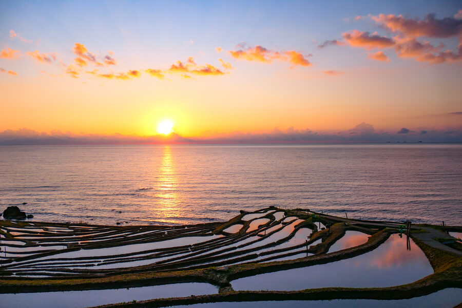
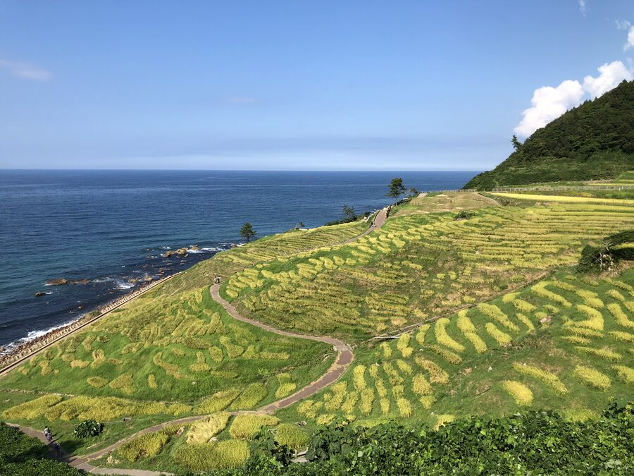
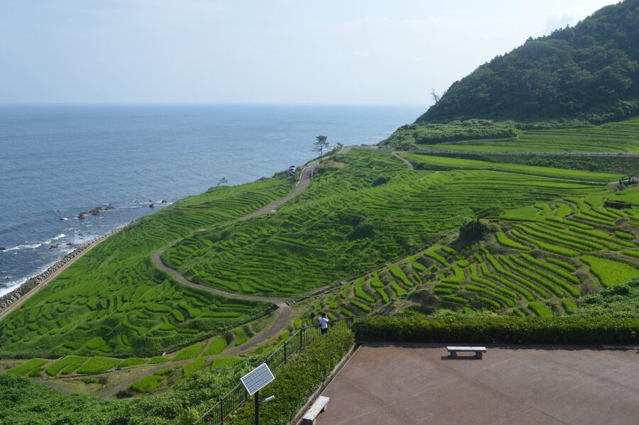
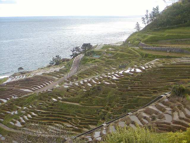
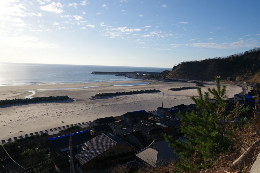
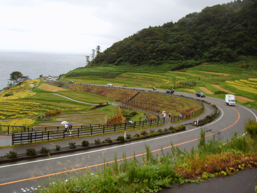
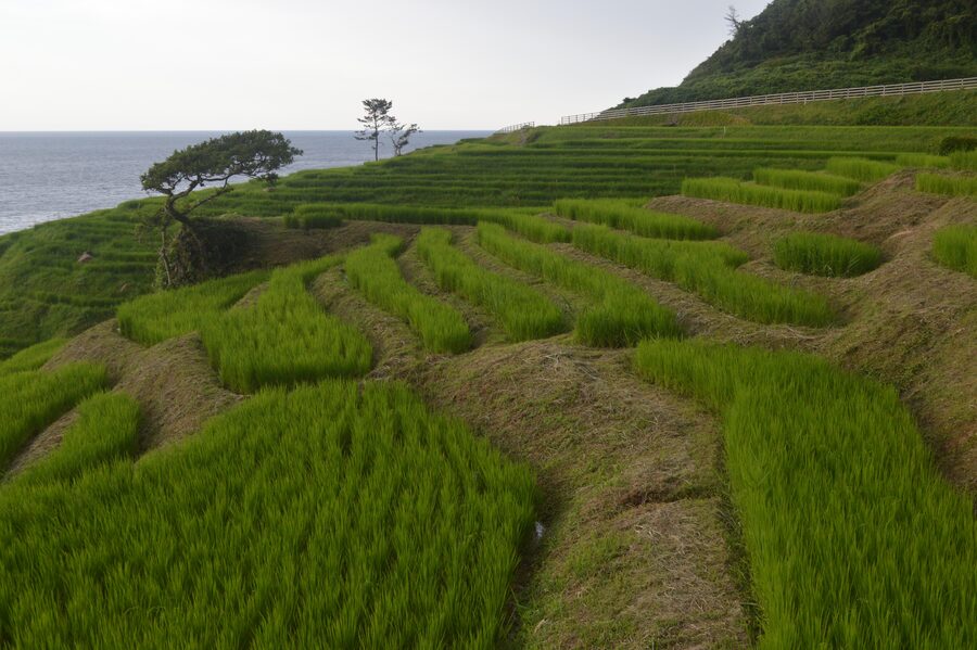
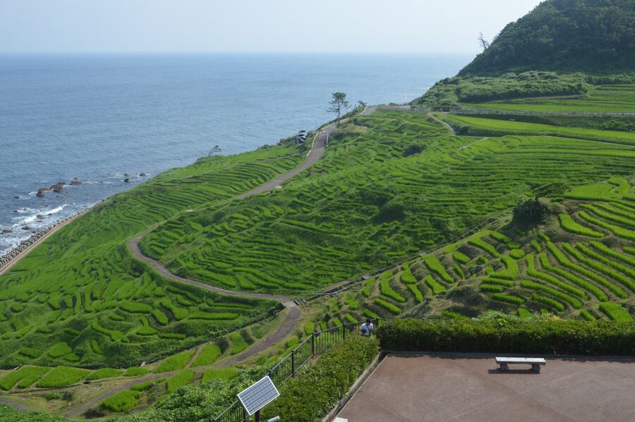
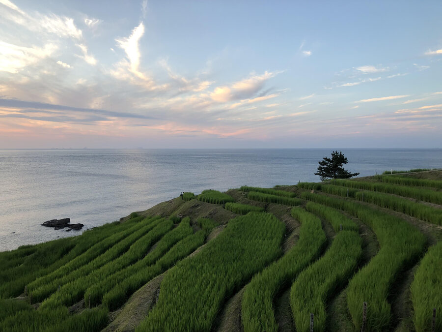
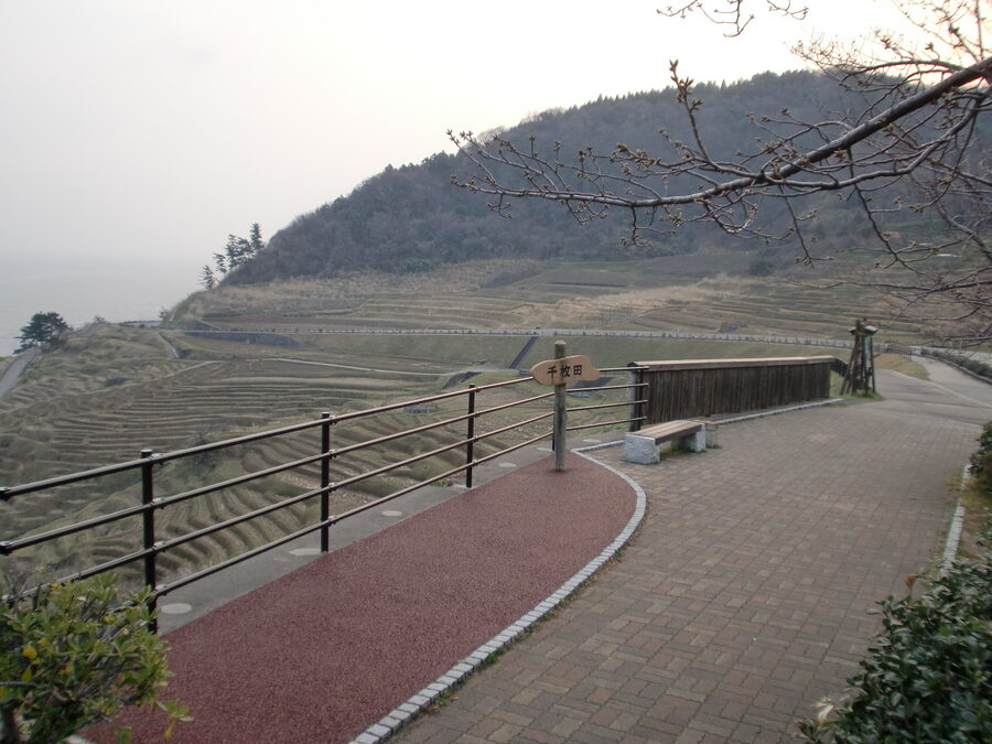
On a 50-metre slope above the Sea of Japan, on the western edge of the Noto Peninsula, there is a hillside cut into 1,004 individual rice paddies. The smallest of those paddies is roughly 50 centimetres on a side, smaller than a folded blanket, and it produces just enough rice for a single bowl. The whole hillside is called Shiroyone Senmaida (白米千枚田), and you cannot drive a tractor through any part of it.
I want to take you to that hillside in this piece, because Senmaida is one of those Japanese landscapes that is much stranger up close than it looks in a photograph. It is a working farm, a national scenic site, a Globally Important Agricultural Heritage System listing, the home of a 25,000-bulb LED illumination called Aze no Kirameki, and, since 1 January 2024, an earthquake-damaged piece of cultural infrastructure that local farmers are quietly putting back together. You also get to read about lacquerware and a thousand-year-old morning market while you are here.
You will find Senmaida in Hakumai-machi (白米町), about 8 kilometres east of the Wajima city centre, on the seaward side of National Route 249. By road, it is about a 90-minute drive from Kanazawa, the old capital of the Kaga domain that ran this coast for the entire Edo period. I will get to that political history later in this piece. First, the slope.
In This Article
- What “Senmaida” Actually Means
- How a Hillside Becomes 1,004 Paddies
- Why You Cannot Mechanise This Slope
- The Owner System (オーナー制度)
- The GIAHS Designation, in Plain English
- Aze no Kirameki: 25,000 Lights on a Slope
- The 1 January 2024 Earthquake
- How to Actually Get There
- The Edo Politics That Shaped the Coast
- Wajima-nuri and the Lacquer Tradition
- The Asaichi Morning Market
- The Senmaida Year in Four Seasons
- How Senmaida Compares to Other Japanese Landscape Sites
- The Hand-Made Nature of the Whole Thing
- Wider Context on the Noto Peninsula
- Eating in Wajima
- Practical Notes for a Single Visit
- Final Thoughts
What “Senmaida” Actually Means
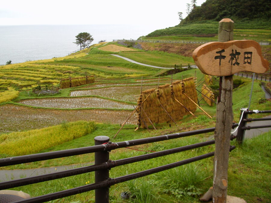
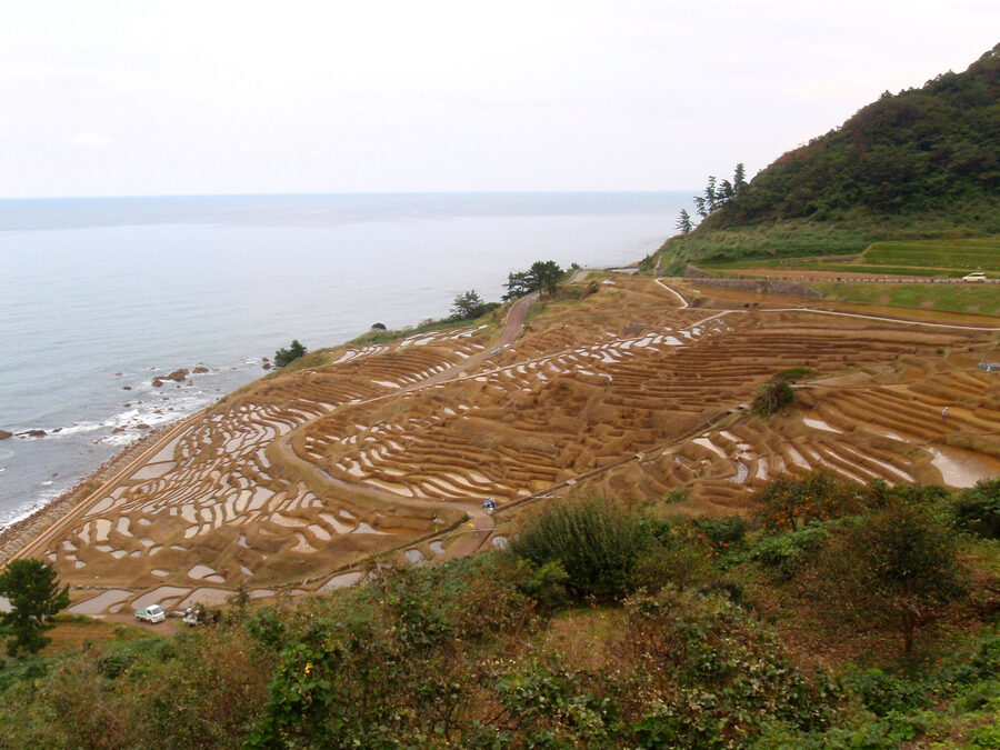
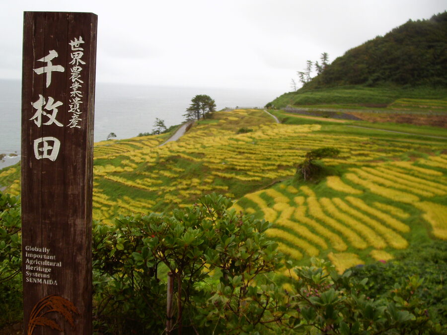
The Japanese word senmaida (千枚田) translates straightforwardly as “thousand-mat rice paddy”, with the character for “mat” (枚) being the counter you use for flat objects. The implication is that the slope holds a thousand individually counted fields. In the case of Shiroyone Senmaida, the implication is exact. Local records from before the 2024 Noto earthquake counted 1,004 paddies on the hillside.
The site sits in a wedge of land where a steep coastal hill drops about 50 metres into the Sea of Japan. The whole terraced area covers roughly 4 hectares, which sounds modest until you notice that the average paddy is about 18 square metres. Some are larger, the size of a small living room. Many are tiny rice handkerchiefs of about 0.2 square metres, hidden between irrigation channels and footpaths.
You sometimes hear the smallest paddies called “raincoat fields” or “straw-mat fields” by old farmers. The story is that a worker would set down a raincoat (a mino, woven from straw) at lunchtime and find a paddy entirely covered. The story is too good to check, but the dimensions are real. I have seen photographs where you can hold the whole paddy in one hand of frame.
How a Hillside Becomes 1,004 Paddies
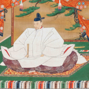
The hillside has been farmed in some form for centuries, but the version you see today is mostly the result of two slow building campaigns and one disaster. The first campaign starts in 1581, when Maeda Toshiie was granted Noto by Oda Nobunaga and began to encourage land reclamation across his new domain. You can read more about Toshiie’s career as the founding lord of Kaga in this site’s piece on the founding of the Maeda house, but for the purposes of this article he matters because his fiscal policy made it worthwhile for villagers in Hakumai to keep adding paddies.
The second campaign was an irrigation project. In 1638, a local engineer called Itaya Hyōshirō completed the Taniyama waterway (谷山用水), which finally fed the upper part of the slope with year-round mountain water. Before Taniyama, paddies above a certain altitude had to rely on rainfall and snowmelt, which is hard to plan a planting around. After 1638, you could in principle keep climbing the hill and adding new fields, and farmers did, generation by generation.
The disaster was a major landslide in 1684. It destroyed a substantial part of the cultivated terraces, and the slope had to be rebuilt by hand. Another quake-driven mountain slide in 1729 did the same thing again. The hillside you see today is the post-1729 reconstruction, very gradually extended outward through the Meiji period as nearby salt-production sites were abandoned and converted to rice.
Why You Cannot Mechanise This Slope
Modern Japanese rice farming runs on tractors, transplanters and combine harvesters. None of those machines fit on the Senmaida slope. The paddies are too small, the gradients between them are too steep, and the irrigation channels run along narrow earth banks (azé, 畔) that would collapse under a tyre. Every step of cultivation here, from puddling the mud in spring to harvesting in late September, is done by hand.
That is not a romantic statement. It is a hard economic fact. A modern Niigata or Akita rice farm produces a kilogram of unmilled rice for under 200 yen of labour.
Senmaida produces the same kilogram at a roughly tenfold labour cost, which is why the slope was nearly abandoned in the 1990s. The fields stayed alive only because Wajima City, Ishikawa Prefecture and a foundation set up in 1993 explicitly took the position that the landscape was worth more than the harvest.
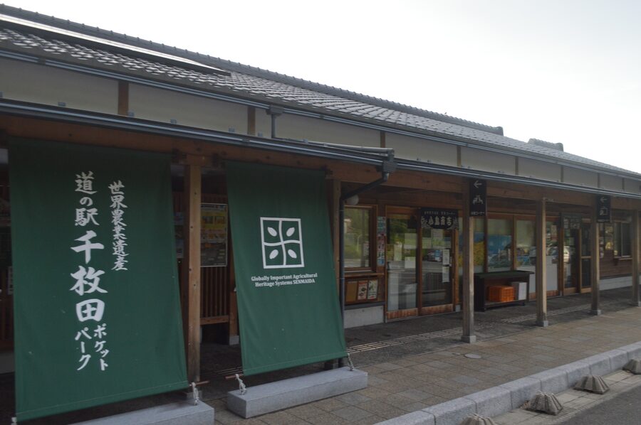
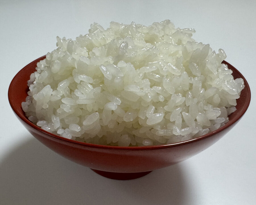
The local rice variety is Koshihikari (コシヒカリ), the same plump short-grain that dominates supermarket shelves in Tokyo. Senmaida Koshihikari is sold at a steep premium under the “Shiroyone” mark, with the implication that the buyer is paying for both the grain and the upkeep of the slope. You can buy a small bag at the Pocket Park rest stop for about 800 yen per 300 grams, which is roughly four times the price of ordinary supermarket rice.
The Owner System (オーナー制度)
In 2007 the local foundation introduced what they call an “owner system” (オーナー制度), which is the closest thing Senmaida has to a sustainable economic model. For around 20,000 yen a year you can sponsor a single paddy. In return you get a name plate on the bank of your paddy, the right to attend the spring planting and autumn harvesting events, and a small bag of rice from your own field at the end of the season.
The numbers are deliberately kept small. Each year a few hundred owners are accepted, and many of them are repeat sponsors. There are paddies under the names of school clubs in Tokyo, of Buddhist temple associations, of one or two minor celebrities, and of an ordinary couple from Yokohama who have held the same patch since 2014. The local farmers do most of the actual work, but the owner system pays a meaningful share of the labour bill.
If you visit during the planting in early May you will see this in operation. Owners arrive in rented rubber boots, the foundation hands out bundles of rice seedlings, and the slope fills up with several hundred volunteers slowly working their way down the field of view, planting one row at a time. It looks chaotic. It is in fact exactly choreographed, because the foundation has been running the same protocol for nearly two decades.
The GIAHS Designation, in Plain English
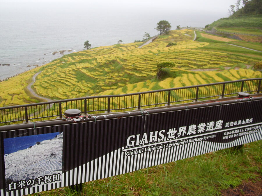
You will see two acronyms attached to Senmaida on every signboard at the site. The first is “国の名勝” (kuni no meishō), meaning “national scenic beauty”. This is a Japanese designation, awarded to Senmaida in 2001 by the Agency for Cultural Affairs, and it is the same legal category that protects places like Matsushima or Kenroku-en. It carries planning restrictions, public funding, and an implicit cultural duty to maintain the look of the place.
The second acronym is GIAHS, for Globally Important Agricultural Heritage Systems. This is a programme run by the Food and Agriculture Organization of the United Nations, and it is best understood as a sort of UNESCO-equivalent for living farms. To qualify, a site has to demonstrate continuous traditional agriculture, biodiversity, valuable knowledge systems and cultural landscapes. In 2011 the FAO inscribed the entire Noto satoyama and satoumi region (能登の里山里海), a wedge of farmed and fished landscape across the peninsula, with Senmaida as one of its keystone sites.
That listing matters more than it sounds. It is one of only a handful of GIAHS sites in Japan, alongside the Aso grasslands and the Shizuoka tea plantations. It puts Senmaida on the same map as the rice terraces of the Philippine Cordillera and the qanat irrigation systems of Iran. In other words, the slope is officially classified as a piece of global agricultural heritage, not just a pretty Japanese landscape.
Aze no Kirameki: 25,000 Lights on a Slope
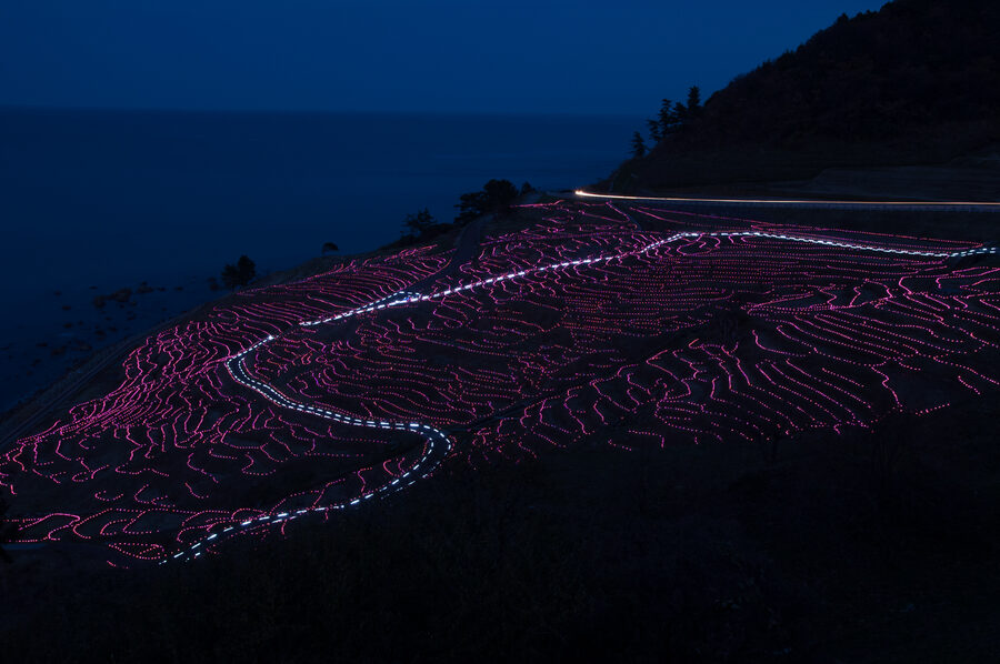
If you only visit Senmaida once, the question of when becomes the most important decision you will make. The summer view is the most photographed, but the winter event is, in my opinion, the strangest and probably the more memorable. Since 2011 the foundation has run an LED illumination called Aze no Kirameki (あぜのきらめき), which translates roughly as “the sparkle of the rice-paddy banks”, and which lasts most of the autumn and winter.
The system uses about 25,000 solar-powered LED globes, charged during the day by panels along the upper slope, and laid out along the earth banks of every paddy. They light up automatically at sunset and run on a 4-hour timer. Every 15 minutes the colour shifts. You see pink, then gold, then ice-blue, then a deep emerald, repeating in slow waves down the slope as if someone were dragging a watercolour brush across it.
In 2012 the system was certified by Guinness as the world’s largest solar-powered LED display. Local Japanese internet users gave it a more affectionate name, ゲーミング田んぼ (“gaming rice field”), in a reference to the colour-cycling RGB lights that gamers attach to their PCs. I think the joke captures something true about the spectacle, which is that it sits halfway between a temple lantern festival and a video-game level select screen.
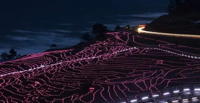
The illumination usually runs from mid-October through mid-March. The exact dates shift each year, partly because the local nights get noticeably colder and partly because the foundation has historically tied the start of the event to the rice-harvest festival schedule. You should always check the Wajima Tourism Association website before you drive up. There were a couple of years post-quake where the slope was lit on a reduced schedule while the foundation rebuilt damaged paddy banks.
A small detail that nobody tells you in the brochures is that the LED globes are not silent. They make a faint hum in the cold, the sort of sound a fluorescent lamp makes when the ballast is old, and after about ten minutes of standing on the overlook you stop noticing it the same way you stop noticing crickets. The first time I read about the event I imagined silence, and the actual sonic profile is gentler and more electric than that.
The 1 January 2024 Earthquake
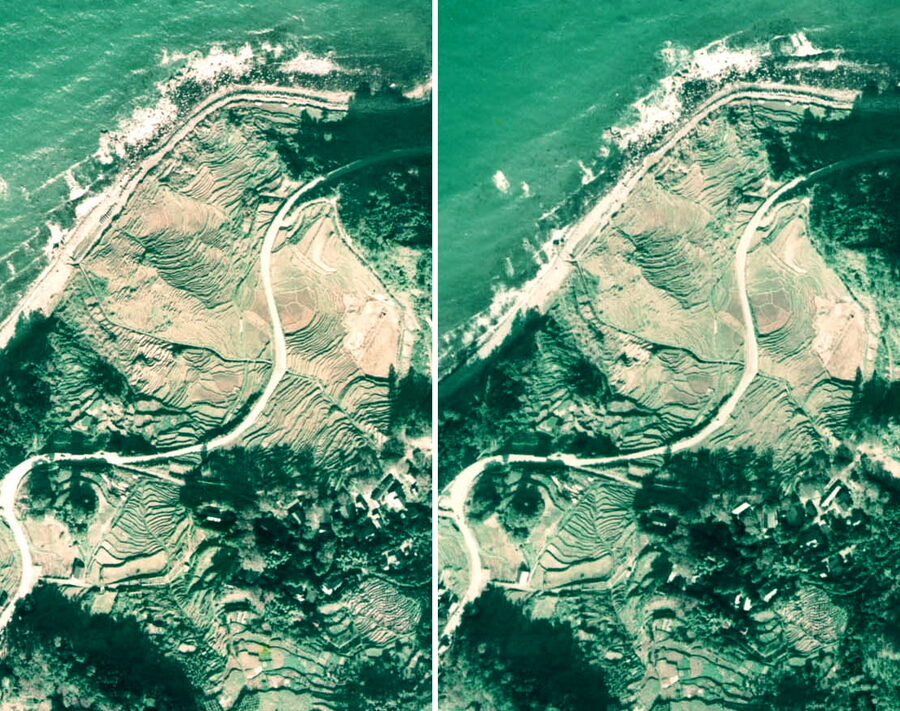
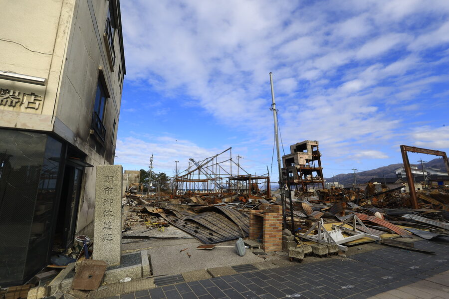
At 16:10 Japan Standard Time on the afternoon of New Year’s Day 2024, a magnitude 7.6 earthquake struck the Noto Peninsula, with its epicentre about 6 kilometres north-northeast of Suzu. The shaking lasted long enough that ordinary residents had time to register that this was an unusually large quake. The depth was around 16 kilometres. It was the deadliest earthquake to strike Japan since the 2011 Tōhoku event.
The numbers, when you list them, are sobering. There were 703 deaths in total across the affected prefectures, of which 241 were in Wajima alone. Some 6,282 homes in Wajima were fully or partially destroyed, and another 4,352 were damaged.
A fire that broke out in the city centre destroyed about 200 buildings, including most of the storefronts on the Asaichi morning market street. The coastline of western Wajima was lifted 4 metres in places by the underlying fault movement, and 85 kilometres of new uplifted shore appeared along the western Noto coast.
Senmaida was directly affected. About 80 percent of the paddies showed cracks in the bank walls or in the irrigation channels. Many of the smaller fields lost their water entirely.
The official paddy count of 1,004 had to be reassessed. As of late 2024 the foundation was reporting that around 120 paddies could be planted with minimal repair, and the rest were in various stages of restoration.
The first post-quake rice-planting day on the slope took place on 11 May 2024, and the first harvest came in on 3 September 2024. A heavy rainstorm on 21 September 2024 caused a fresh embankment collapse and reset the recovery clock.
If you visit now, the slope still works as a landscape. The visible damage at the top of the field, near the Pocket Park, is mostly cleared. Lower down, you can spot dry paddies and patched bank walls if you look.
The foundation has been candid about the long timeline. Full restoration of all 1,004 paddies will take, by their own published estimate, somewhere between five and seven years from the quake date.
I want to be careful with the tone of this section. The earthquake killed several hundred people on this peninsula, and the slope is, in the end, a piece of farmland. Visitors who are sensitive about the still-recent disaster sometimes prefer to wait.
I think the more useful thing to know is that the foundation, the city government and the local rice farmers have explicitly asked tourists to keep coming, because the visitor revenue is part of the rebuild plan. Buying a bag of Shiroyone rice at the Pocket Park is, in a small way, voting for the slope’s continued existence.
How to Actually Get There
Wajima has no passenger rail service. The old Noto Line was retired in 2001, and you cannot get to the city by train. Your options are a long bus ride from Kanazawa, a flight into Noto Airport (1 hour from Tokyo Haneda) followed by a 30-minute taxi or rental car, or a road trip down the Notoji Driveway and along National Route 249.
If you are coming from Kanazawa with a rental car, allow about 2 hours each way. The route runs north on the Notoji Driveway expressway for about 75 kilometres, exits onto the Anamizu interchange, then turns coastal on Route 249 and follows the western shoreline up to Wajima. About 8 kilometres before you reach the city centre, you will see the brown national-scenic-beauty signs for Senmaida, and the slope opens up below the road on your left.
The Pocket Park (道の駅 千枚田ポケットパーク) is the official viewing point and rest stop. There is parking for around 50 cars. There is a small café, a souvenir kiosk, public toilets, and a viewing terrace that hangs over the very top edge of the slope.
The terrace is wheelchair-accessible. There is no entry fee. Most visitors stay for 20 to 40 minutes, which is plenty in summer and probably too short on a cold winter night when the LEDs are on.
Public bus service from Wajima to Senmaida runs about hourly during daylight hours on the Hokutetsu Bus “Machinopia” line, which loops out to the slope and back. The fare is around 480 yen one way. If you are timing a winter LED visit, the bus does not run late enough to take you back into Wajima after dark, so you either drive yourself or arrange a taxi. The Wajima Tourism Association keeps a running list of taxi operators that will accept the run.
I want to mention one practical safety note. The slope sits on a sea-cliff that, as the 2024 quake demonstrated, is geologically active. The Pocket Park overlook is engineered for that, but the unmaintained footpaths down into the paddies are not. The foundation politely asks visitors to stay on the marked paths, partly for safety and partly because casual foot traffic damages the bank walls that farmers have to repair by hand.
The Edo Politics That Shaped the Coast
Senmaida did not develop in a vacuum. The slope sits inside what was, for almost the entire Edo period, the Kaga domain (加賀藩), which was the largest non-Tokugawa fief in Japan, with an official kokudaka of more than a million koku. The Maeda family ran it from Kanazawa Castle for thirteen generations, and Wajima was an outlying district roughly as far from the castle as you could be while still being inside the same domain.
That distance mattered. The Maeda kept Wajima in the loop politically through a system of regional commissioners, and they used the village rice tribute, including some of the harvest from Hakumai, to feed the official Maeda processions to and from Edo under the alternate-attendance policy. You can read about the mechanics of those processions in the site’s piece on sankin-kōtai, but the relevant detail for Senmaida is that the slope’s harvest, however small, was politically tagged, not simply local food.
Geographically, the Hokuriku coast in this period was an interconnected economic zone. North along the coast from Kaga was Etchū Province, which the Sassa Narimasa article covers in detail, and the daimyō networks in Toyama and Wajima exchanged rice, lacquer and salted fish as a matter of routine business. A rice farmer on the Senmaida slope in 1700 would have known that some of his harvest was destined for kitchens hundreds of kilometres away.
Wajima-nuri and the Lacquer Tradition
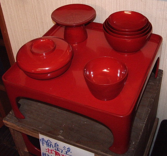
You cannot really write about Wajima without mentioning the lacquer. Wajima-nuri (輪島塗) is one of Japan’s most distinctive lacquer traditions, and the city has been making it for at least seven hundred years. The technique is built on a base coat that mixes raw lacquer with finely powdered diatomaceous earth (jinoko, 地の粉), which produces a notably tough, scratch-resistant finish. The earliest archaeologically attested Wajima-nuri object is a 14th-century shrine door fragment in the city’s collection.
The full Wajima-nuri process traditionally requires more than 100 individual steps, spread across half a year. There is a wood-shaping stage, a base-coat stage with multiple sandings, an undercoat stage, several layers of red and black middle coats, and a final decorative stage that may include maki-e (蒔絵) gold-flake painting or chinkin (沈金) carved-and-inlaid gold linework. Different specialist craftsmen do different stages, and very few workshops produce an entire piece in-house.
This matters for the Senmaida visit, because the slope and the lacquer industry share an economic logic. Both depend on small-scale skilled handwork that does not respond well to mechanisation, both are kept alive partly by national heritage policy, and both took significant damage from the 2024 earthquake.
The Wajima-nuri Kaikan museum was hit. Several historic workshops on the Asaichi street were destroyed in the post-quake fire. The recovery overlap with Senmaida is more than thematic, it is administrative, with the same prefectural budgets restoring both.
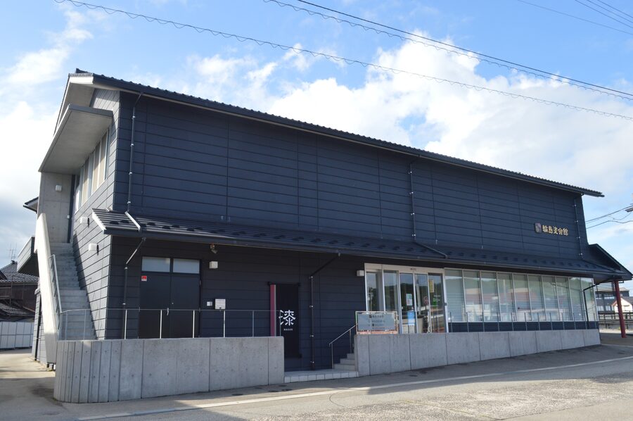
If you have time after the slope, I recommend the Wajima-nuri Kaikan in central Wajima, on Kawai-cho (河井町). The building reopened in stages after 2024 quake repairs, and as of this writing it is running a reduced exhibition with detailed explanation panels. Tickets are around 600 yen. They will sometimes have a lacquer artisan on site doing live chinkin work, and watching the gold being burnished into the cut grooves of a finished bowl is, I think, one of the best small experiences available in northern Ishikawa.
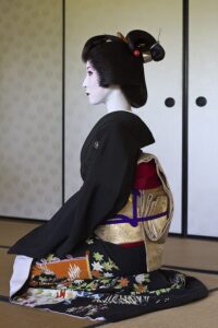
If you eat a meal at almost any Wajima inn or restaurant, you will be served on Wajima-nuri. The bowls, trays and chopstick rests are essentially never decorative-only. They are working tableware, used at every meal, and the patina that builds up after a few decades is part of the appeal. The rice in your bowl will probably not be Senmaida Koshihikari unless you pay specifically for it, but the bowl itself is overwhelmingly likely to have been finished within five kilometres of the slope.
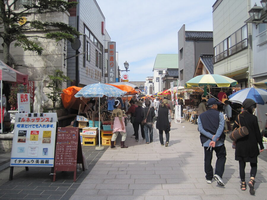
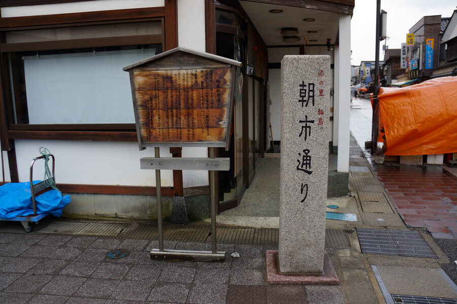
The Asaichi Morning Market
The Wajima Asaichi (輪島朝市) is a thousand-year-old morning market that has run every morning except the 10th and 25th of each month for as long as anyone can establish in writing. The earliest documentary references are early Heian, around the 1100s. Until 1 January 2024 the market ran on a single several-hundred-metre street in central Wajima, and on a normal morning you would find around 200 stalls selling fish, vegetables, lacquerware, knives, and seaweed.
The earthquake fire on 1 January 2024 destroyed about 200 buildings on or beside the Asaichi street. Many of the historic shopfronts that hosted the market are now cleared lots. The municipal government has announced a phased reconstruction, and a temporary version of the market is being run from a smaller indoor venue while the street is rebuilt. As of this writing, around 50 stalls are operating.
If you are in Wajima before 11:00 on any day other than the 10th or 25th, the temporary market is worth visiting. The vendors are mostly the same families who have been working the original street for generations. They are happy to talk about which boats brought in which fish that morning, and the prices, by Tokyo standards, are excellent. The rebuild plan calls for the original street to reopen in stages by 2027, and I am cautiously optimistic about that timeline based on the resources the prefecture has committed.
One small thing that visitors often miss is the etiquette. Asaichi vendors expect you to bargain a little, and they will quote you a slightly higher opening price than they expect to receive. A 10 to 20 percent discount on the second offer is normal.
Anything over that is rude, and the vendor will politely ignore you. If you do not bargain at all, that is also fine. They will charge you the opening price without complaint.
The Senmaida Year in Four Seasons
The slope changes character through the year, and you should pick your visit based on what you actually want to see. Spring brings the planting, with the paddies flooded and reflective and the seedlings still short. Summer fills out the green.
Autumn brings the harvest, with the hazagoshi drying frames and the cleared paddies. Winter brings the LED illumination and a stillness that no other season offers.
For sheer photographic drama, the best two windows are mid-May, when the paddies are flooded and you get the sky-mirror effect, and mid-October when the harvest is in and the slope is striped with empty fields. Mid-July through mid-August is the most uniformly green, and the most popular with domestic Japanese tourists, so the Pocket Park parking lot will be full by 9:00. Winter brings the smallest crowds, and the LED experience is usually less than a third of full Pocket Park capacity.
If you are picking a single window for a first visit, I think the best balance of weather, scenery and crowd density is the second week of October. The harvest is just finishing, the air is clear, the slope is striped with golden post-cut paddies, and the LED illumination has just started. You can drive up in the late afternoon, walk the slope before sunset, and watch the LEDs come on while you eat a small dinner at the Pocket Park café. There is something pleasant about the seasonal transition being visible inside one visit.
The hazagoshi drying-frame moment is brief, usually under two weeks. The frames go up immediately after the cut and come down once the rice has finished drying in the heads. If you want to see them, I suggest aiming for the third week of September. Local farmers’ Twitter (now X) accounts post the day the frames go up, and the foundation sometimes posts a notice on the Wajima Tourism Association website.
How Senmaida Compares to Other Japanese Landscape Sites
You can usefully compare Senmaida to the famous formal gardens of central Japan, and the comparison is illuminating. Both are highly artificial landscapes that pretend to be natural, both are maintained by hand at considerable cost, and both rely on a kind of disciplined patience that is hard to fake. The major difference is that a Senmaida paddy is a working economic unit, while a Kenroku-en pond is purely aesthetic.
If you have ever visited the gardens covered in the site’s piece on Japan’s greatest gardens, you will already have a feel for the kind of planning that goes into Senmaida. The slope is laid out the way a stroll garden is laid out, with each viewpoint deliberately framed and each transition prepared. The difference is that gardeners are working at the scale of a single tree, while at Senmaida the unit of design is the rice paddy, and the gardener is the entire village.
You can also compare Senmaida usefully to Japan’s seasonal landscapes. The cherry-blossom moment described in the site’s sakura piece turns the country pink for ten days a year, and Senmaida turns the slope mirror-blue for about two weeks every May. Both events are short, both depend on the weather, and both bring out crowds. The difference is that hanami is for everyone with a Wikipedia article on Japan, and Senmaida planting day is for the foundation’s three or four hundred subscribed paddy owners. The slope is an exclusive event by accident of scale.
The Hand-Made Nature of the Whole Thing
I want to end on the texture of the work, because it is the part of Senmaida that is hardest to convey in photographs. The slope exists only because every step in its maintenance is human.
The bank walls are repaired by individual farmers using clay, straw and bamboo stakes. The irrigation channels are cleared every spring with bamboo brooms. The seedlings are placed by hand in May.
The cut rice is hung on hazagoshi frames by hand in September. The threshing is done at the edge of the slope by small portable machines that are brought in field by field.
None of those steps is technically interesting on its own. Together, across 1,004 paddies, they produce something that looks effortless from the road but is in fact a continuous low-level act of maintenance involving most of the village. There is something about that work that ties Senmaida to other hand-craft traditions of Hokuriku. The same village that grows the rice still finishes the lacquer, and the same conservative attention to small repeated steps shows up in both.
You can see this same logic at work in the Japanese kawara roof-tile tradition, where every individual tile has to be laid by a specialist whose work you barely notice unless something goes wrong. There is a certain pride in being unobserved that I think runs through all three trades, lacquer, rice and tile. The skill is in the consistency, not the show, and the show is what survives across centuries.
Wider Context on the Noto Peninsula
The peninsula itself is worth a paragraph or two, because Senmaida is a single point on a much larger heritage map. Noto sticks north into the Sea of Japan from central Honshū, with a coastline that runs about 280 kilometres around. It is divided in local usage into Kuchi-Noto, Naka-Noto and Oku-Noto, the third of which contains Wajima and the slope. The whole peninsula was inscribed by the FAO as a GIAHS site in 2011, the same year Senmaida itself received recognition.
The economic mix on the peninsula is agriculture, fisheries and tourism, in roughly that order. The Sea of Japan side, where Senmaida sits, has the most dramatic scenery and the smallest year-round population. The Toyama Bay side, on the eastern edge, has more towns, more rail, and the city of Nanao with its Wakura Onsen hot-spring district. There is a reasonable argument that the western side feels like the deep countryside that the eastern side gestures at.
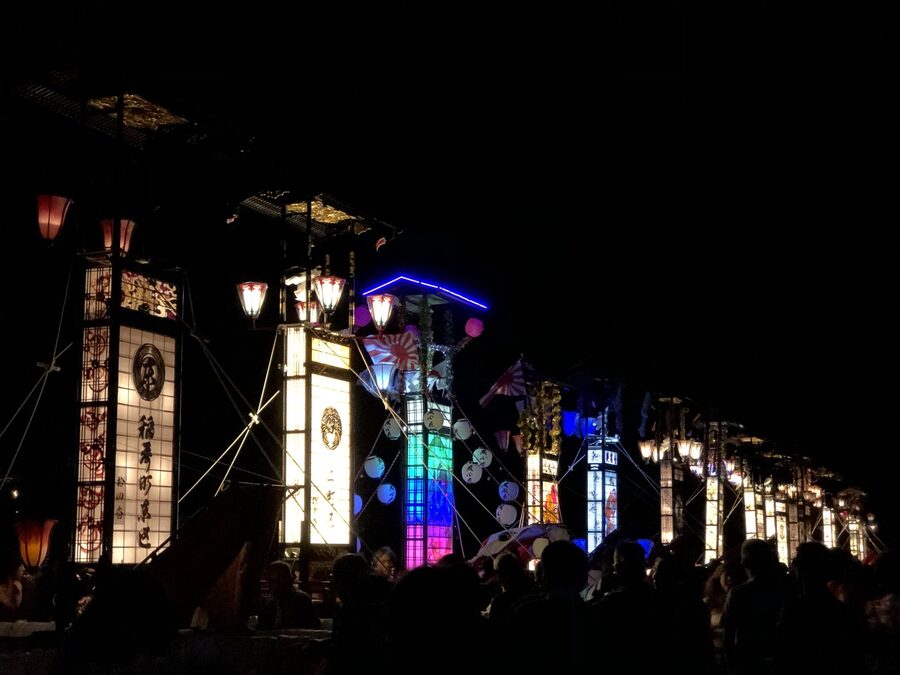
The peninsula is also notable for traditional festivals. The Wajima Taisai every August features tall lantern floats called kiriko (キリコ), some over 10 metres high, processed through the streets at night with taiko drummers at the base. There is a dedicated kiriko museum in the city, the Wajima Kiriko Kaikan, which was damaged in the 2024 quake but is reopening in stages. If you visit between mid-July and early September, the festival calendar across Noto is dense enough that you can usually see one without specifically planning for it.
The peninsula is also part of the broader Japanese coastal landscape that the Sea of Japan winters define. From late November through March, the western coast gets the heavy snowfall that drifts in off the sea after passing over Sakhalin and Vladivostok. Wajima averages 2,300 millimetres of precipitation a year, much of it as winter snow. The Aze no Kirameki LED illumination overlaps with the season when much of the slope is, on any given week, briefly white.
Eating in Wajima
The food, briefly, because it is a real reason to stay overnight. Wajima inns serve a Sea of Japan breakfast that revolves around grilled mackerel, pickled vegetables, miso soup with seaweed, and rice from one of two or three local growers. Several of those growers have paddies on the Senmaida slope, and you can usually ask the inn whether the rice you are eating is Senmaida-grown. The honest ones will tell you no.
For dinner, the Sea of Japan winter brings out fugu, ankō, kanburi (winter yellowtail), and snow crab. A serious crab dinner at a Wajima ryokan during the December-to-February peak season runs around 25,000 yen per person and is, for what you get, surprisingly good value. The crabs are landed at Wajima Port a few hours before they hit your table, and the kitchens are not coy about how recently each leg was alive.
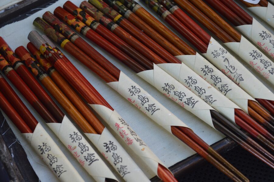
One detail that ties the whole landscape together for me is the chopsticks. At a serious Wajima dinner you will probably eat with Wajima-nuri chopsticks, lacquered locally, picked up at the morning market by the inn’s owner. You will eat off Wajima-nuri trays.
The food on those trays comes from the Sea of Japan you can see from the slope. The rice may have come from the slope itself. The whole meal is, in a small way, a single landscape served in one sitting.
Practical Notes for a Single Visit
If you have one day for Wajima and Senmaida, the schedule that works best in my experience is to arrive in the city by 7:30, walk the temporary Asaichi market until 10:30, drive out to the slope by 11:00, spend an hour on the overlook, eat a Pocket Park lunch, and head into the Wajima-nuri Kaikan for a 14:00 demonstration if you can get one. That gets you the three principal experiences with time built in for the unexpected.
Cash is more useful than cards in most parts of Wajima. The market vendors take cash. Small inns prefer cash.
The Pocket Park café accepts both, but the souvenir kiosk only takes cash for the rice purchases. The nearest 7-Eleven ATM is about 10 kilometres back toward Anamizu. Pull cash before you commit to the Wajima loop.
Mobile coverage is good on Route 249 itself but variable in the Wajima city centre, especially after the 2024 quake disrupted local infrastructure. If you are using a navigation app, save a backup paper map. The roads bend along contours, the signage is mostly in Japanese, and the drive becomes much harder if the GPS drops out at the wrong intersection.
Final Thoughts
I keep coming back, in this piece, to the idea that Senmaida is a deliberately uneconomic landscape. The slope produces too little rice, with too much labour, to ever pay for itself in pure agricultural terms.
Every actor involved knows this. The local farmers know it. The foundation knows it. The Ishikawa prefectural government knows it, and the FAO knows it, which is part of why GIAHS exists in the first place.
What the slope produces, instead, is a kind of cultural information. It tells you what Japanese rice farming looked like before mechanisation, what the Hokuriku coastline looked like before consolidation, what 1,004 hand-built paddies feel like when you walk along their banks.
That information is fragile. The 2024 earthquake nearly broke the system that delivers it. The fact that it is still arriving, in patches, on the recovering slope, is one of the reasons I think Senmaida is worth a visit now rather than five years from now.
Go in October, if you can, when the harvest is just in and the LEDs are just starting. Stand on the Pocket Park overlook for at least 20 minutes. Buy a small bag of the rice.
Talk to the kiosk attendant about which paddy your bag came from, because they often know, and they will sometimes tell you. Then drive into Wajima for dinner at a ryokan that uses Wajima-nuri tableware, and let the entire small landscape arrive in one sitting.
The slope has been there since the 17th century in roughly its current shape. It will, if the foundation and the city government are right about the rebuild timeline, still be there for the rest of this century and well beyond.
You are simply going to see it at a particular point in its long arc, in the years just after a major earthquake, when the people who maintain it are working harder than usual to keep it visible. That is a reasonable thing to witness. It is also, as Japanese landscapes go, an unusually quiet, unusually small, unusually private kind of place to spend a slow afternoon.